The NASA-ISRO Synthetic Aperture Radar (NISAR) satellite represents one of the most ambitious Earth observation missions ever undertaken, embodying a groundbreaking partnership between the United States and India to revolutionize our understanding of Earth’s dynamic surface. With a launch scheduled for July 30, 2025 at 5:40 PM IST from Sriharikota, NISAR marks a historic milestone in international space cooperation.
Mission Genesis and International Partnership
The NISAR mission emerged from the 2007 National Academy of Sciences decadal survey, which identified critical Earth observation priorities including ecosystem dynamics, crustal deformation, and cryospheric sciences. Following extensive discussions between NASA and ISRO, the partnership was formalized on September 30, 2014, when NASA Administrator Charles Bolden and ISRO Chairman K. Radhakrishnan signed the collaborative agreement in Toronto.
This partnership represents more than just technological cooperation—it establishes a strategic alliance that leverages the complementary expertise of both agencies. The mission concept specifically addresses ISRO’s scientific interests in agricultural monitoring, landslide studies, Himalayan glaciers, soil moisture assessment, and coastal processes.
Technical Specifications Satellite Configuration
NISAR is a massive Earth observation satellite with impressive specifications:
- Mass: 2,392 kg
- Dimensions: About the length of a pickup truck
- Orbit: Sun-synchronous polar orbit at 747 km altitude with 98.4° inclination
- Repeat cycle: 12 days with 6 AM/6 PM nodal crossing
- Mission duration: Minimum 3 years for NASA requirements, 5 years for ISRO requirements
Dual-Frequency Radar System
NISAR’s most revolutionary feature is its world-first dual-frequency Synthetic Aperture Radar (SAR) system, combining NASA’s L-band and ISRO’s S-band radars:
L-Band SAR (NASA):
- Wavelength: 24 cm (1.257 GHz frequency)
- Array elements: 24 transmit/receive elements in 2 rows
- Primary functions: Deep vegetation penetration, landscape topography, interferometric analysis
- Coverage: Global operations for NASA science requirements
S-Band SAR (ISRO):
- Wavelength: 12 cm (3.2 GHz frequency)
- Array elements: 48 transmit/receive elements in 2 rows
- Primary functions: Light vegetation monitoring, coastal processes, polar region observations
- Coverage: Focused on Indian subcontinent and specific science areas
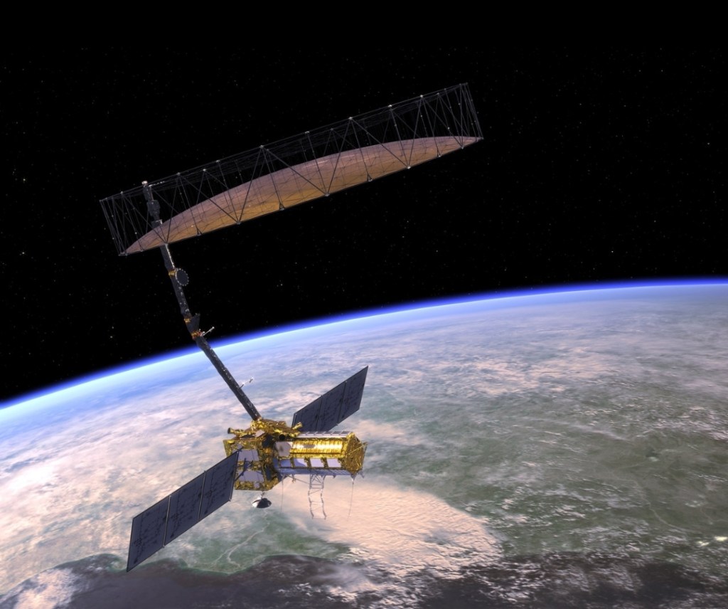
Antenna Reflector System
The satellite features a 12-meter deployable mesh reflector antenna—the largest ever launched by NASA—mounted on a 9-meter boom. This gold-plated wire mesh reflector is shared by both radar systems and enables the mission’s wide-swath imaging capabilities.
SweepSAR Technology Innovation
NISAR employs the revolutionary SweepSAR technique, making its space-based debut with this mission. This innovative approach:
- Transmits: Using all array elements simultaneously to create a narrow beam illuminating the full 242-km swath
- Receives: Sweeps the beam across the reflector to listen for returning echoes
- Processes: Combines returning signals in real-time for gapless imagery
This technology enables simultaneous wide-swath coverage (>240 km) and high resolution (3-10 meters), overcoming traditional SAR limitations.
Scientific Objectives and Applications
Primary Scientific Goals
NISAR addresses three fundamental Earth science domains:
Solid Earth Dynamics:
- Monitor earthquake cycles, volcanic deformation, and landslide kinematics
- Detect land subsidence from groundwater extraction and tectonic processes
- Measure surface deformation with millimeter-level accuracy
Ecosystem Monitoring:
- Track forest biomass changes and carbon storage dynamics
- Monitor agricultural productivity and crop health
- Assess wetland and permafrost ecosystem variations
- Detect deforestation and vegetation changes
Ice Dynamics and Climate:
- Study ice sheet response to climate change
- Monitor glacier retreat and polar ice movement
- Track sea ice interactions with climate patterns
- Assess impacts on global sea level rise
Applications and Societal Benefits
Disaster Response and Hazard Monitoring:
- Real-time tracking of earthquakes, volcanic eruptions, and landslides
- Early warning systems for natural disasters
- Infrastructure monitoring for dams, bridges, and urban areas
- Rapid damage assessment following catastrophic events
Climate and Environmental Monitoring:
- High-precision tracking of climate change indicators
- Glacier and ice sheet monitoring for sea level projections
- Ecosystem health assessment and biodiversity tracking
- Environmental policy support through data-driven insights
Agricultural and Water Resource Management:
- Crop assessment and irrigation planning
- Soil moisture monitoring for precision agriculture
- Water resource management and aquifer monitoring
- Food security applications through crop yield predictions
Data Products and Distribution
Data Volume and Processing
NISAR will generate an unprecedented 80 terabytes of data products daily—more than any previous Earth satellite from either NASA or ISRO. This massive dataset requires innovative cloud-based processing and distribution systems.
Data Product Hierarchy
The mission will produce structured data products across multiple levels:
- Level-0: Raw radar signal data
- Level-1: Single Look Complex (SLC), Multi-Look Detected (MLD), interferograms, and polarimetric covariance images
- Level-2: Geocoded Level-1 products
- Level-3: Large area radiometric terrain corrected mosaics
- Level-4: Science products in physical units
Open Data Policy
NISAR maintains a comprehensive open data policy, ensuring all science data from both L-band and S-band systems will be freely available to the global scientific community. Data will be accessible through:
- NASA: Alaska Satellite Facility Distributed Active Archive Center (DAAC)
- ISRO: Bhoonidhi portal
- Distribution timeline: 1-2 days after observation, with emergency data available within hours
Mission Development Timeline and Challenges
Development History
The NISAR mission has faced several technical challenges and delays throughout its development:
2014-2021: Initial development phase with payload integration at NASA JPL
2021: COVID-19 impact resulted in 7-month delays and $36 million additional costs
2023-2024: 12-meter antenna reflector issues required return to NASA for thermal coating upgrades
2024: Final integration completed at ISRO’s Bengaluru facility
2025: Current launch readiness with final pre-launch preparations
Technical Innovations and Challenges
The mission’s complexity stems from several groundbreaking technologies:
- First dual-frequency space-based SAR system
- Largest deployable antenna reflector ever launched by NASA
- SweepSAR technique space debut
- Advanced digital beam forming and on-board processing
Launch and Operations
Launch Configuration
NISAR will launch aboard ISRO’s GSLV-F16 from the Second Launch Pad at Satish Dhawan Space Centre. The satellite was encapsulated in its payload fairing on July 18, 2025, in preparation for the July 30 launch.

Orbital Operations
Following a 90-day commissioning period, NISAR will begin its primary science mission. The satellite will:
- Scan Earth’s surface every 12 days with both ascending and descending passes
- Sample locations on average every 6 days due to overlapping coverage
- Operate in left-looking mode with precise pointing control (±273 arcseconds)
- Cover >240 km swaths with resolutions between 3-10 meters depending on mode
Global Impact and Future Prospects
NISAR represents more than a technological achievement—it embodies a new paradigm for international scientific cooperation and Earth system science. The mission’s comprehensive Earth monitoring capabilities will provide unprecedented insights into climate change, natural hazards, and ecosystem dynamics, supporting evidence-based decision making for global challenges.
With its revolutionary dual-frequency radar system, innovative SweepSAR technology, and commitment to open science, NISAR will establish new standards for Earth observation missions and strengthen the foundation for future NASA-ISRO collaborations in space exploration.
The mission’s success will not only advance our scientific understanding of Earth’s dynamic systems but also demonstrate the power of international partnerships in addressing humanity’s most pressing environmental and societal challenges.
#NISAR #NASA #ISRO #EarthObservation #SyntheticApertureRadar #Satellite #ClimateChange #DisasterResponse #RemoteSensing #SpaceTechnology #DisasterManagement #SpaceTechnology #ClimateMonitoring #InfrastructureMonitoring #GlobalOperations #DataAnalytics #SpaceCollaboration #BusinessContinuity #RiskManagement #EnvironmentalIntelligence #SyntheticApertureRadar #OpenData #Innovation


Hello. Thanks for visiting. I’d love to hear your thoughts! What resonated with you in this piece? Drop a comment below and let’s start a conversation.